

PnBear
-
Posts
1721 -
Joined
-
Last visited
-
Donations
0.00 USD -
Points
965,100 [ Donate ]
Content Type
Profiles
Forums
Gallery
Twitch
Running Commentary
Events
Store
Downloads
Everything posted by PnBear
-
lol
-
hehehehe......Bet Bud gets a little less miles per gallon
-
??? this September 9th
-
Microsoft says the term "gay" is unacceptable in any circumstance
PnBear replied to LiquidStool's topic in General Discussion
funny Statistics & Facts The population of Fort Gay is approximately 852 (1990). The approximate number of families is 391 (1990). The amount of land area in Fort Gay is 2.054 sq. kilometers. The amount of surface water is 0.15 sq kilometers. The distance from Fort Gay to Washington DC is 321 miles. The distance to the West Virginia state capital is 57 miles. (as the crow flies) Fort Gay is positioned 38.11 degrees north of the equator and 82.59 degrees west of the prime meridian. Location Fort Gay location: in the southeastern part of the county, near the border of Kentucky History & History Related Items Fort Gay history: The first settler in the area was Samuel Short who came about 1796. His cabin was built near where Fort Gay stands today. In 1789, Charles Vancouver and 10 companions built a log fort and attempted a settlement on land surveyed in 1770 by John Frye for George Washington. The town was initially known as Cassville and became the first incorporated town in the area. The incorporation date was 13 November 1875. The first mayor was Jas. H. Marcum. The recorder was John C. romans and the councilmen were Calahan Beaire, Wayne Ferguson, William H. Frasher, Stephen M. Marcum and Samuel Short. In 1883, a fire destroyed almost the entire business section. -
and one use xfire on blackberry...so i can fark off some more at work.
-
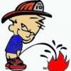
Fear the the bear we shit in the woods
-
heck yea on the hump day !!!!!!!
-
hahaha.......
-
woot !!! ConGrats !!!!
-
COD4 MW2 Freezetag server is up
PnBear replied to Ruggerxi's topic in Call of Duty 4's Call Of Duty 4 Discussion
overgrown....yea thats the map -
COD4 MW2 Freezetag server is up
PnBear replied to Ruggerxi's topic in Call of Duty 4's Call Of Duty 4 Discussion
it ws on a stock map....to early cant think of the name. the one with gandma's house/wood bridge and concrete bridge -
did they sell it at hole sell..or rip.. you off. so this means no half ass job now. thats toooo funny.... hope your not on fuuny people at walmart http://www.peopleofwalmart.com/?page_id=9798
-
6 TRUTHS OF LIFE 1. You cannot stick your tongue out and look up at the ceiling at the same time. 2. All idiots, after reading #1 will try it. 3. And discover #1 is a lie. 4. You are smiling now because you are an idiot. 5. You soon will forward this to another idiot. 6. There is still a stupid smile on your face I apologize about this but I'm an idiot and I needed company.
-
COD4 Star Wars mod is back
PnBear replied to Ruggerxi's topic in Call of Duty 4's Call Of Duty 4 Discussion
i have fun....some of the maps would be a cool freeze tag cross over -
welcome.....and a new target
-
o no....what a place to put a plug ..hehe
-
thats great....keep us up to date
-
I'v been looking for that house for 21 years now....someday i hope
-
looks like 3 of you need the metals. Great job
-
NuttCutter......woot welcome
-
welcome Wild You, Show Off First post we get Booty ....please post more
-
shawskank redemption we were sholders harts war blazing saddeles bridge over the river kwai most all steve mcqueen movie most all jack nicholson Fridays
-
ok...help me out a little what is it ? I know a mod for what game.
-
lol...true so very true
-
NEW RULE: IF YOU LEAVE >XI< THE DOOR IS CLOSED ON COMING BACK
PnBear replied to Ruggerxi's topic in User Announcements
ok i'm in